
THIS WEEK: Take the long way home
FLYING LESSONS uses recent mishap reports to consider what might have contributed to accidents, so you can make better decisions if you face similar circumstances. In most cases design characteristics of a specific airplane have little direct bearing on the possible causes of aircraft accidents—but knowing how your airplane’s systems respond can make the difference in your success as the scenario unfolds. So apply these FLYING LESSONS to the specific airplane you fly. Verify all technical information before applying it to your aircraft or operation, with manufacturers’ data and recommendations taking precedence. You are pilot in command and are ultimately responsible for the decisions you make.
FLYING LESSONS is an independent product of MASTERY FLIGHT TRAINING, INC.
Pursue Mastery of Flight®
This week’s LESSONS
Take the Long Way Home
It was a routine work flight in my employer’s Beech A36 Bonanza: an early-morning hour from home base at Wichita, Kansas to Olathe up in the Kansas City area. The air was breathtakingly smooth and cool on the way up at 9000 feet, with scattered areas of patchy fog below hugging the few reservoirs along the way.
After an interesting and informative day, I briefed for the late afternoon flight home. Kansas is in a period of frequent thunderstorms, often heavy and sometimes severe, with massive rainfall amounts. I’d been wondering all week if I would be able to fly or if I should drive the three hours up for my meeting. It looked like we would have a bit of a respite that day, however. I saw a heavy line of storms on radar about 200 miles west of Wichita before I left home that morning, but it wasn’t moving much and my experienced “gut feel” was that it would wear itself out shortly after sunrise and not build up again until early evening. Just another June day in Kansas.
I told my wife before I left that I was flying, not driving, and in a worst-case scenario I’d rent a car and drive home that night. “Aim for the blue,” she told me, an old blessing between us that came from a Thanksgiving weekend flight several years ago. Sure enough, as I flew up to New Century Aircenter (KIXD) a look rearward on my trusty Garmin 796’s Sirius/XM Weather confirmed my decades-old feel for Great Plains thunderstorms was correct (and very different behavior from other regions of the country). The walls of red and yellow echoes were becoming spotty, shrinking blotches of green.
Even so, my hosts at Olathe made an unsolicited offer to put the company airplane in their hangar and even keep it there for a couple of nights if I needed to fall back to renting a car to drive home. Thanks! Mid-afternoon, I checked weather and saw the green blotches were beginning to sprout…still well away from my route.
Meetings done, and catching up to my preflight briefing for the flight home: The pattern remained the same, isolated blotches of precipitation, now with some small areas of yellow within the green returns. A thicker and heavier line was organizing maybe 150 miles west and northwest of home, but that would not get to Wichita for several hours. A few blossoms were beginning to bunch up closer to the west of Wichita, however. The observations (METARs and AWOS) at home (KAAO) and nearby (KICT) were starting to include marginal VFR ceilings. A little west of that they were confirming light rain, lower bases and reduced visibility.
Visual avoidance is the only truly safe way to operate near turbulent clouds of vertical development without on-board real-time weather radar (and the training to master it). My plan, as it always does, included a way out. So far, a direct line KIXD-KAAO looked clear on radar. I could go about halfway, to Emporia, Kansas (KEMP), and land there if needed. I could always turn around and come back to the rental-card rich environment of Kansas City. A right turn to Salina, Kansas (KSLN) was open and would put me about 90 minutes’ drive from home. Topeka, Manhattan and an array of other airports were there for the landing. I had lots of “outs,” all solid gold. So I filed and launched.
OK, maybe my weather gut was off after a nice lunch from my hosts. After a few traffic-related vectors and altitude restrictions I was “direct to” at 8000 feet. Two fingers of precipitation had begun to develop, gathering little cells into stronger ones on either side of KAAO. They joined a larger “hand” of yellow precipitation west of Wichita that was moving oh so slowly east. More was forming along and north of my route. For a while it looked like I could aim south and then fly up a wide slot from the southeast to home. But I didn’t like that things were building earlier than I had expected. The whole area was not huge, but it was beginning to go where I wanted to be.
So almost as soon as I called out “Checklist Complete” after level-off I radioed Kansas City Center: “I’d like to amend my route and go direct ANTON, direct HUT and then direct destination for weather avoidance.” ATC immediately granted my revised route.
I don’t like to ask to “deviate.” I’d rather evaluate conditions and tell Air Traffic Control what I want to do and where I want to go. It allows me better maintain position awareness and to input something into the navigator that I or the autopilot can follow. I think controllers like that too, instead of watching a radar blip meander unpredictably across their scope. My new route looked like this screen shot I took shortly after making the turn toward ANTON:
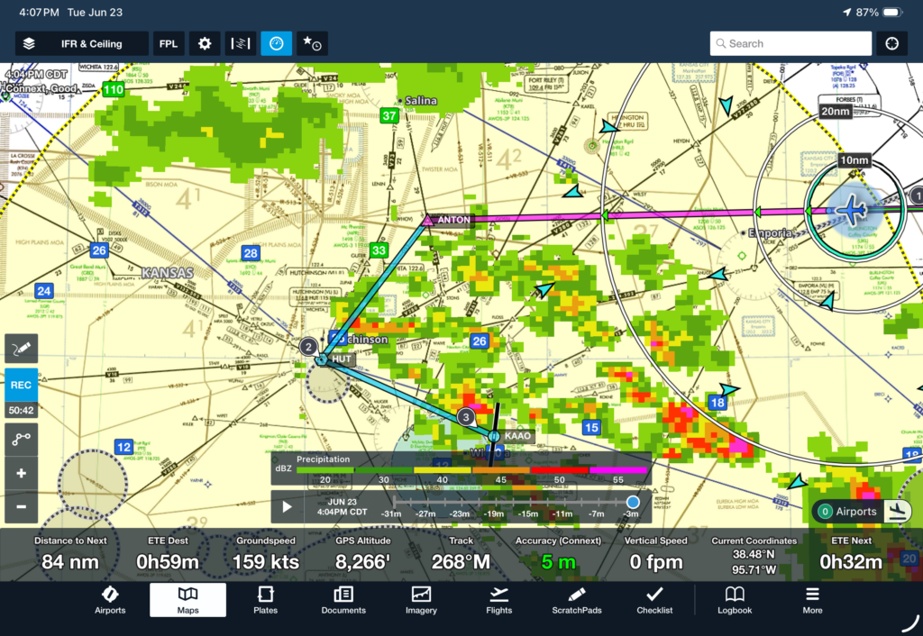
My strategy was to stay in clear air and fly around the whole threat, coming back in behind the weather as it continued to drift slowly northeast. I still had multiple ways out at every step of the way. It looked like I could even get into Wichita Eisenhower (KICT) without entering precipitation if Jabara (KAAO) was still covered when I got there.
The pattern was moving so slowly, in fact, that once I got due north of the red and yellow cell about halfway to ANTON I slowed down to cruise about 20 knots slower—not for turbulence, because the air was completely smooth, but to give the weather more time to drift east before I turned around it to fly in from the west. I’ve mentioned this before in FLYING LESSONS Weekly: “the miracle of flying slowly.”
Still, the cell north of Hutchinson (HUT) was so slow that I knew before I turned at ANTON that I needed to go a little further west. Immediately after making the turn toward HUT, I called Center: Request 20 degrees right of course for 25 miles, then direct Hutchinson then direct destination. ATC granted that request to and confirmed about 20 miles should do it: Deviation approved, when able turn to 180 degrees and anticipate direct Jabara.
Not long after making my turn to due south a little north of Hutchinson, both Sirus/XM and ADS-B and, more importantly because it was real-time radar, Wichita Approach (to whom by then I was speaking) agreed a straight shot to ZUXEG, the Initial Approach Fix (IAF) on the western end of the classic GPS T-shaped approach, would keep me out of the echoes. I activated the approach and turned toward the IAF. Asking for a lower altitude (I was still at 8000 feet), but knowing from experience, I wouldn’t be permitted much lower until I had passed the approaches to Eisenhower Airport, I re-briefed the RNAV (GPS) 36 approach for descent into the reported 1200-foot overcast and three miles’ visibility.
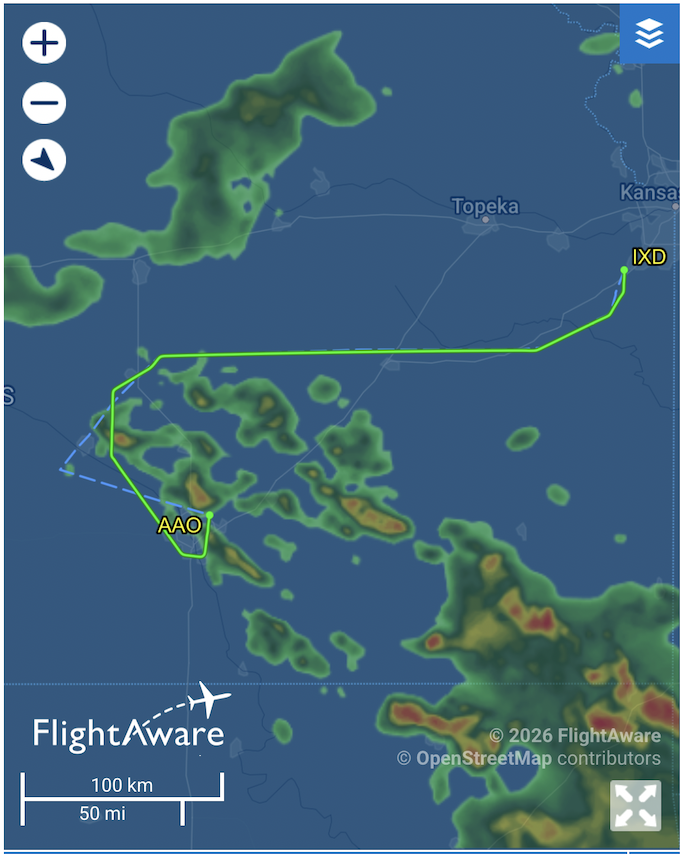
Weather on FlightAware screen shots is not entirely accurate. The yellows and reds were further away to the east-northeast as I came around the west side and flew the approach into Wichita’s Jabara Airport.
A business jet ahead of me on the approach didn’t report any trouble, and after its crew cancelled their instrument clearance I was cleared for the approach. Even then I consciously thought, if it starts to get rough I’ll turn west and ask to land at Eisenhower for a quick Uber ride to my car at Jabara. I flew the approach, broke out about 1100 feet above ground level with a clear view of the Precision Approach Path Indicator lights and the runway ahead of me. I called in the height of the cloud bases when I radioed Approach to cancel my IFR clearance.
Just this week I’ve spoken with two pilots who routinely fly into backcountry airstrips, often in mountains and sometimes with one-way and (after a point) no-go-around approaches. I’ve talked with a pilot who competes in short takeoff and landing contests. I got a repeat offer to come fly seaplanes into small, remote lakes, and I’ve emailed with several pilots preparing for a mass arrival formation flight into Oshkosh next month. I remembered that, although personal issues prevented me from going to the east coast to do it, this is the week I was supposed to fly with a friend in his 100-year-old Ford Trimotor. For me flying’s greatest challenge and reward is the “head game” of making strategic and tactical decisions before and during a tricky IFR flight and wielding the skill to fly with precision where risk management and my decisions take me—including at times to an enroute alternate, and sometimes to a hotel or a car rental counter.
Each of these types of flying—every type of flying—holds excitement for some pilots but may disinterest and even scare away others. Regardless of the type of flying you do, be it in the IFR system or visually, into short airstrips or Class B primary airports, in the newest or in ancient but well-maintained airframes, or surrounded by other airplanes in an extended voluntary near-miss all headed the same direction, the same basic rules apply:
1. Plan your flight and fly your plan.
2. Notwithstanding rule 1, be prepared and willing to change the plan before conditions require you to do so.
3. When facing a threat, be it thunderstorms, mountains, traffic or otherwise, keep the threat visually in sight to maneuver away from as your best defense.
4. Never cede command of your aircraft. Tell controllers what you need and want, and where you’ll go. Ask for information you need to make better decisions, but don’t think others can make them for you. There is no provision in civil aviation for delegating pilot-in-command responsibility to someone outside your aircraft.
5. Know the direction to immediately improving conditions at all times. If despite your best mitigations you encounter conditions worse than you are able to handle having a pre-planned tactic of “turn west and aim for XX” is golden.
6. If you don’t have a “golden” way out, don’t go in.
The more you fly the more likely it is you’ll have to change plans. For me this week slowing down for a while in cruise to allow the biggest threat to move away, skirting weather visually until all I faced was a post-rainfall stratus layer well within my current capabilities and that of the airplane I was fortunate to be flying, and taking the long way home allowed me to make it home in time for dinner.
Next time the exercise starts over. Just because I made it home this time doesn’t mean I’ll be able to next time. I get to pursue the same Mastery of Flight challenges every time I fly.
Questions? Comments? Supportable opinions? Let us know at [email protected].


Share safer skies. Forward FLYING LESSONS to a friend.
Please help cover the ongoing costs of providing FLYING LESSONS through this
Or send a check made out to Mastery Flight Training, Inc. at 247 Tiffany Street, Rose Hill, Kansas USA 67133.
Thank you, generous supporters.
Thank you to our regular monthly financial contributors:
Steven Bernstein, Montclair, NJ. Robert Carhart, Jr., Odentown, MD. Greg Cohen, Gaithersburg, MD. John Collins, Martinsburg, WV. Dan Drew. Rob Finfrock, Rio Rancho, NM. Norman Gallagher. Bill Griffith, Indianapolis, IN. Steven Hefner, Corinth, MS; Ellen Herr, Ft Myers, FL. Erik Hoel, Redlands, CA. Ron Horton. David Karalunas, Anchorage, AK. Steve Kelly, Appleton, WI. Karl Kleiderer. Greg Long, Johnston, IA. Rick Lugash, Los Angeles, CA. Richard McCraw, Hinesburg, VT. David Ovad, Resiertown, MD. Steven Oxholm, Portsmouth, NH. Brian Schiff, Keller, TX. Paul Sergeant, Allen, TX. Paul Uhlig, Wichita, KS. Richard Whitney, Warrenton, VA. Jim Preston, Alexandria, VA. Johannes Ascherl, Munich, Germany. Bruce Dickerson, Asheville, NC. Edmund Braly, Norman, OK. Steven Hefner. Lorne Sheren, New Vernon, NJ. “The Proficient Pilot,” Keller, TX. Kynan Sturgiss, Hereford, TX. Bluegrass Rental Properties, LLC, London, KY. John Foster. Joseph Victor, Bellevue, WA. Chris Palmer, Irvine, CA. Barry Warner, Yakima, WA. Todd LeClair, Cadiz, KY. Jim Hopp, San Carlos, CA. Adrian Chapman, West Chester, PA. Ed Stack, Prospect Heights, IL. Robert Finley, Dubois, Wyoming. Robert Finley, John Kinyon, Lawrence Copp, V. Andrew Smith, Kevin Echols. Claude Bundrick, Shreveport, LA. John Croft, Upper Marlboro, MD. Robert Hoffman, Sanders, KY.
Thank you to these 2026 donors:
Robert Sparks, Mark Sletten, Thomas Jaszewski, Douglas Olson, David Field, Michael McRobert, Wayne Colburn. Albert Chaker, Textron Aviation Employees Flying Club, Denny Southard, Henry Fiorentini, Thomas Fankhauser, Rob Humble, Nandakumar Sankaran, Jay Apt, Bill Farrell, Stu Spindel, Robert Holtaway, George Stromeyer, John Whitehead
Pursue Mastery of Flight®
Thomas P. Turner, M.S. Aviation Safety
Flight Instructor Hall of Fame Inductee
2021 Jack Eggspuehler Service Award winner
2010 National FAA Safety Team Representative of the Year
2008 FAA Central Region CFI of the Year
FLYING LESSONS is ©2026 Mastery Flight Training, Inc. For more information see www.thomaspturner.com. For reprint permission or other questions contact [email protected].