

THIS WEEK: >> Debrief-a-thon

FLYING LESSONS uses recent mishap reports to consider what might have contributed to accidents, so you can make better decisions if you face similar circumstances. In most cases design characteristics of a specific airplane have little direct bearing on the possible causes of aircraft accidents—but knowing how your airplane’s systems respond can make the difference in your success as the scenario unfolds. So apply these FLYING LESSONS to the specific airplane you fly. Verify all technical information before applying it to your aircraft or operation, with manufacturers’ data and recommendations taking precedence. You are pilot in command and are ultimately responsible for the decisions you make.
FLYING LESSONS is an independent product of MASTERY FLIGHT TRAINING, INC.
Pursue Mastery of Flight®
This week’s LESSONS
Let’s catch up on your insights and go straight to the Debrief.
Questions? Comments? Supportable opinions? Let us know at [email protected].

Debrief
Readers write about recent LESSONS:
Reader Jim Pitman wrote me this week to introduce Go-Arounds Are Awesome, an educational effort aimed at reducing the number of Loss of Control-Inflight crashes that occur during go-arounds, as well as runway excursions and overruns that happen after a pilot lands far beyond the intended touchdown spot or delays executing a go-around when one is warranted. Specifically it’s “A movement to encourage better pilot decision-making and performance.”

I’ve taken the pledge and you should too. Check it out.
Go-Arounds Are Awesome comes on the heels of the similar education-and-pledge based Put Your Gear Down campaign to reduce gear up and gear collapse events. If you fly, maintain or teach in retractable gear airplanes visit the PYGD website and take that pledge as well.

A reader who wishes to remain anonymous writes about the August 14 LESSONS stemming from the crash of a medivac King Air during a period of GPS anomalies intentionally applied by the Federal government:
Your antennae twitches about the awful medevac King Air crash on arrival to Ruidoso, NM are spot-on. The crew took off briefed and aware of a NOTAM about GPS interference testing at White Sand Missile Range, a common occurrence there, whose area encompassed their home base. The only real debate is about whether they lost what you would call command of the airplane about 15nm into their planned 70nm flight, or whether they took off without that command.
Look at the ADS-B Exchange, Juan Browne’s YouTube, or both. The crew spent the entire flight with their heads ten miles behind the airplane—again, on a short flight— in their own familiar patch of Earth. That will never work. It can’t. Stay ahead.
They didn’t need GPS to do what they sought to do. But they flew through the localizer they were seeking, and were cleared for, by about ten miles, then turned back toward it eventually but did not fly all the way back toward it, then descended visually toward runway lights…In the dark, among mountains, miles off the Loc course. They were an accident looking for a rock to hit and they found one. Were they trying and failing to use the GPS that the NOTAM had warned against, or were they otherwise simply lost in their home neighborhood? Don’t know which of those is true or which of them is worse.
Keep command, always. Control is easier. And this crew had control. But control wasn’t enough. Command!
Thank you, anonymous.
Reader/instructor Mike McNamara adds:
Your discussion on losing GPS is right on.
When I give flight reviews and IPCs I often simulate total loss of GPS. The pilot will often say, “Not fair, that will never happen.” Then I tell the story.
A few years ago I was flying around the Northeast to 5 or 6 different airports for various reasons. VFR weather. I fly with 4 GPS devices: Garmin 530W, Aera 660, iPhone, iPad. On one of the legs one of the devices lost position. I landed, it came back.
On the next leg, 2 other devices lost position. Then came back. On the last leg, all devices lost position. Other pilots were having no problem.
I called the avionics shop. They said, “Yeah, we know about that problem. The Garmin 530W has an active antenna. If it gets water infiltration, it can fail and turn into a GPS jammer. Newer antennas don’t do that.”
It’s always good to know the gotchas. Thank you, Mike.
Frequent Debriefer and SABRIS Aviation owner/instructor Dave Dewhirst continues:
C90 Accident Ruidoso, NM (KSSR) 5/14/2026
This is an early analysis based on limited available data.
The aircraft was equipped with Garmin GNS530/430 GPS/Nav navigators, Sandel EHI and conventional nav displays. The flight was planned from ROS to SRR, a flight time of 30 minutes. SRR has a GPS approach. It is likely the flight was planned direct PLATS for the RNAV 24 approach.
It appears the flight departed ROS, initiated a right turn to the west and maintained a sustained climb. At some point shortly after takeoff, GPS data was lost or compromised. It is likely the clearance was changed to present position direct REYOK for the beginning of the ILS approach. It is not likely the pilot planned to use the ILS approach from the beginning because the RNAV approach is a shorter flight. The problem appears to be that he was aware the GPS data was not available and he knew he needed to fly the ILS approach. A likely problem is without GPS, he could not locate REYOK. It is not known if nav assistance was provided by Center.
It is likely that he was in the vicinity of REYOK when he began the approach, and, based on the flight path, he may have had the city in sight. Whatever happened at that point indicates that he may have not had use of the localizer signal, drifted west of course, descended early, and at 9,300 feet, hit the 10,300 [foot] mountain. The approach plate shows to use the SSR DME when flying the approach. It is not known if the DME in this airplane can be separately tuned or is simply channeled to use the DME provided by the ILS station. That signal would have helped prevent the error on step down.
We teach to have every device tuned to something meaningful, even if is redundant. We have had five failures of the nav function in G530 navigators. It happens even without jamming. Therefore, we have an alternate plan in place. For example, in this case, the pilot could have had the #1 nav tuned to the ILS and the #2 nav tuned to the CME VORTAC with the OBS set on 308 degrees. That is V68 and leads to REYOK. With a GPS failure, the pilot makes a right turn northbound to intercept V68 to REYOK and completes the ILS approach.
I want to add something more: We teach that situations will happen where the pilot is /unsure/ of [position, navigation, procedure, anything]. The question is, what should the pilot do at that point? Continuing under the present situation will produce an untoward result, like flying into a mountain. We teach the following:
1. Climb to an altitude that should produce terrain clearance.
2. Slow down. There is no point in burning fuel or going fast into the unknown.
3. Point the airplane in a direction of safety. That may be away from terrain or controlled airspace.
4. Tell ATC that you are /unsure/ [of something]. The reason for using that term is that I have heard it used. ATC understands that the pilot needs help without it being specific. They do not want to call Search and Rescue or vector other traffic.
The exact problem can be determined later. ATC appreciates the alert that a problem is about to happen and knows where the pilot can be vectored to sort out the problem. In the case of the Ruidoso crash, it should have occurred to the pilot or to ATC that a vector to the southeast at 12,000 was the best idea until the GPS or navigation issue could be resolved.
It will be interesting to see how much of that may be reflected in the NTSB’s final report, Dave. Regardless, thanks for reinforcing the wisdom of, as you say, hav[ing] every device tuned to something meaningful.
Here’s some personal experience from reader Gary Whittaker:
Thanks for the interesting discussion on training for loss of GPS. I have lost GPS guidance on multiple flights and for different reasons. Living in coastal North Carolina we are in the affected area of military caused outages that cover large areas. On an IFR flight to the northeast while still in central NC I lost GPS due to one of these exercises. I advised ATC and continued in heading mode until I got the signal back, which took awhile. I attempted to switch to VOR navigation as I have two working nav radios in the airplane but could not find a working VOR. Because I learned to fly more than 40 years ago I got into the habit of using VORs to cross check my position and I still do on every cross-country flight. As I travel around the country it has gotten hard to find working VORs. While the notion of transitioning to ground based navigation sounds great the reality is we are losing the needed VOR’s to make that transition.
On another occasion the antenna of my primary GPS failed. Fortunately, the GTN 750 [Garmin NAV/COM] was designed with this failure mode in mind and it switched to an internal pilotage mode but that will not work for an approach. As I was navigating direct to destination when it failed it got me there. Again, I was in an area where there were no working VORs to provide backup ground based navigation.
As a result of this experience I now have two completely independent GPS units and two independent ILS receivers for approaches in the event GPS is down but that assumes radar coverage and working communication. I also fly with a handheld radio in my flight bag in the event of lost communication. If both GPS and radar/radio communication go down a pilot in IMC could be in trouble if they are planning to rely on VOR navigation. Seems like we should be brushing up on our pilotage skills as well.
Thank you for your insights, Gary.
Reader Andris Golde addresses our final approach configuration discussion from recent LESSONS:
As always, I appreciate the effort and depth of detail in your writings. My verbal checklist on short final always includes saying out loud “Red, Blue, Green” on final while I confirm the controls visually. The color mnemonic refers to having set the red mixture control properly for altitude and performance requirements, the blue control for propeller RPM to land or go around, and finally the three green lights on the landing gear indicator. Plenty of time to adjust them in a few seconds or make the decision to go around.
If I recall correctly, Bruce Williams suggested this trick in one his many instructional videos that I watched years ago. It saved my bacon once when I was distracted by both ATC and the Tower controllers contradicting each other on a very busy day at my home airport KPDK. However, all pilots should know that their “Numbers” need be spot on for landing. If they are not, immediately see what’s wrong and act appropriately.
And “acting appropriately” would mean executing a go-around, then figuring it out once at a safe altitude. Thank you, Andris.
Reader, retired commercial pilot and active flight instructor Dan Drew continues on both landing configuration confirmation and flying in a degraded GPS environment:
I have had the extreme pleasure (and sweating) of learning formation from [Debriefer John] “Weebs” [Weibener] and I too have incorporated some of the “hints” of usage of the gear. I like what he said George Braly said of “Is this plane ready for takeoff?” and “Is this plane ready to land?” and will stress that to myself and to my students.
In reading this article about GPS outages and almost more importantly GPS degradation causes me to really think about my plane. I have dual [Garmin] G3Xs [Primary Flight Displays] and a GNC215 for a secondary comm/nav radio. I also have a GNC 750Xi [GPS nav/comm] and have only somewhat recently learned where to get VOR or fix information to determine the bearing and distance using it. The GNC 215 has the ability to tune and select a bearing/radial [but] there is no traditional CDI. I use the 750 and the G3X mainly but with the 215 I have to tune a frequency, push the volume button to take it out of Comm into NAV and it will give me an arrow pointing to the direction of the radial…some of my cross countries I get over to it and play to try to imagine how would I get somewhere if everything else failed. After many years of full glass, partial glass and steam gauges (I remember when my commuter airline got the first PN 101- we thought we were in the big time with it).
The basic premise is, at least to me, put the latest in and you start a whole new era of learning a new way to look at the same old information…and sometimes in the case of this week’s talk…you better know what you have, how to recognize problems and how to revert to somewhat steam to get to the ground in one piece.
Now I have to go and practice what you talked about so when I call you for an IPC I can blow your socks off!!!!!
I look forward to it, Dan. And thank you for your observations and advice as well.
And New Zealand reader Pieter van Ammers also adds:
Once again thank you for a fantastic piece of writing, with so much wisdom. Really enjoyed the link to “Children of the Magenta Line.”
[I] also agree that fatalism over gear ups is foolish. As an an anesthesiologist, would you like me to manage your care with a heavy dose of fatalism? Methinks not! So why should aviation be any different?
Always good to look in from outside the bubble, Pieter. Thank you.
And Swedish reader Peter Baron adds his personal experience with GPS outages:
Following on from your discussion of GPS interference, I experienced an example of malicious interference earlier this year while flying in southeast Sweden. My flying partner and I were flying from Kalmar (ESMQ) to Eslöv (ESME) in our Socata TB10. This is a fairly simple 170nm, straight line flight over flat terrain, enlivened only by the need to request transits through the CTRs of Ronneby and Kristianstad.
We had a Garmin 430 in the panel and portable devices driving moving maps on iPads and all of them began producing anomalous indications about 30 minutess after takeoff. If the displays were to be believed, we were flying somewhere in the vicinity of Kaliningrad [Russia] (see picture. The blue line is the “track” the GPS recorded).
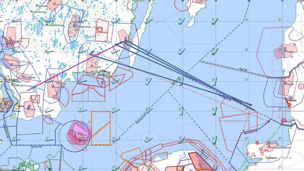
When the initial alarm subsided, we realised that:
1. There were two of us in the cockpit and we’re both of the generation that never sets foot in the aircraft without a paper log. My friend in the left seat flew the planned heading while I looked for navigation plan B.
2. We were in excellent VMC and the coastline, major highways and lakes were all easily identifiable.
3. A moving map display, even without GPS, is still a map and on an iPad it’s easy to measure distances and bearings.
4. The plane has VOR, ADF and DME and Ronneby and Kristianstad have NDBs and DME.
5. We were in radio contact with radar units who could provide vectors when needed.
One shouldn’t over dramatise this. The sun was shining, there were no mountains and there were plenty of good, non-GPS navigation options available, so we were never in any serious trouble but the initial dislocation was significant. Having two of us meant that one could aviate while the other navigated and this was probably the biggest factor that helped us. It did act as a reminder though and I remain grateful for having had it drummed into me as a student pilot that one must always have a pilot log for any cross country flight and, even when following a magenta line, be aware of landmarks and beacon transits.
In many countries the number of ground-based navaids is reducing as expensive, power and maintenance-hungry transmitters are, understandably, taken out of service. Given the likely increase in disruption of satellite-based navigation systems this must be a cause for concern.
Thank you for the detailed and illustrated LESSON, Peter. It’s a great example of crew resource management even in a light, fixed gear airplane.
Wrapping it up for this week, reader, retired controller, corporate jet pilot and NTSB News Talk podcaster Rob Mark homes in on a comment I made in the GPS-related discussion:
I just finished this week’s Mastery LESSON and one phrase you used really stuck in my head …“I’m curious.” When I was still flying professionally, I remember how easy it was to be lulled into boredom during long legs.
To keep my mind alert, I used to tune in VORs and NDBs for cross bearings just so my mind knew, “Ah… we’re right there,” for the same reason you mentioned. I was curious too.
When I fly with others, I notice how often they punch in the destination, set the autopilot and then mention the time remaining until arrival. They might look out the window, but I know they seldom really know our position. I still like cross checks even when I’m flying the sim.
Thanks for mentioning the importance of being curious.
Thank you, Rob.
More to say? Let us learn from you, at [email protected].
Share safer skies. Forward FLYING LESSONS to a friend.
Please help cover the ongoing costs of providing FLYING LESSONS through this
secure PayPal donations link.
Or send a check made out to Mastery Flight Training, Inc. at 247 Tiffany Street, Rose Hill, Kansas USA 67133.
Thank you, generous supporters.
Thank you to our regular monthly financial contributors:
Steven Bernstein, Montclair, NJ. Robert Carhart, Jr., Odentown, MD. Greg Cohen, Gaithersburg, MD. John Collins, Martinsburg, WV. Dan Drew. Rob Finfrock, Rio Rancho, NM. Norman Gallagher. Bill Griffith, Indianapolis, IN. Steven Hefner, Corinth, MS; Ellen Herr, Ft Myers, FL. Erik Hoel, Redlands, CA. Ron Horton. David Karalunas, Anchorage, AK. Steve Kelly, Appleton, WI. Karl Kleiderer. Greg Long, Johnston, IA. Rick Lugash, Los Angeles, CA. Richard McCraw, Hinesburg, VT. David Ovad, Resiertown, MD. Steven Oxholm, Portsmouth, NH. Brian Schiff, Keller, TX. Paul Sergeant, Allen, TX. Paul Uhlig, Wichita, KS. Richard Whitney, Warrenton, VA. Jim Preston, Alexandria, VA. Johannes Ascherl, Munich, Germany. Bruce Dickerson, Asheville, NC. Edmund Braly, Norman, OK. Steven Hefner. Lorne Sheren, New Vernon, NJ. “The Proficient Pilot,” Keller, TX. Kynan Sturgiss, Hereford, TX. Bluegrass Rental Properties, LLC, London, KY. John Foster. Joseph Victor, Bellevue, WA. Chris Palmer, Irvine, CA. Barry Warner, Yakima, WA. Todd LeClair, Cadiz, KY. Jim Hopp, San Carlos, CA. Adrian Chapman, West Chester, PA. Ed Stack, Prospect Heights, IL. Robert Finley, Dubois, Wyoming. Robert Finley, John Kinyon, Lawrence Copp, V. Andrew Smith, Kevin Echols. Claude Bundrick, Shreveport, LA. John Croft, Upper Marlboro, MD. Robert Hoffman, Sanders, KY.
Thank you to these 2026 donors:
Robert Sparks, Mark Sletten, Thomas Jaszewski, Douglas Olson, David Field, Michael McRobert, Wayne Colburn. Albert Chaker, Textron Aviation Employees Flying Club, Denny Southard, Henry Fiorentini, Thomas Fankhauser, Rob Humble, Nandakumar Sankaran, Jay Apt, Bill Farrell, Stu Spindel, Robert Holtaway, George Stromeyer, John Whitehead, Wayne Colburn, Kevin O’Halloran, Dale Kitchens, Tom Carr, Lauren McGavran, David Clark
Pursue Mastery of Flight®
Thomas P. Turner, M.S. Aviation Safety
Flight Instructor Hall of Fame Inductee
2021 Jack Eggspuehler Service Award winner
2010 National FAA Safety Team Representative of the Year
2008 FAA Central Region CFI of the Year
FLYING LESSONS is ©2026 Mastery Flight Training, Inc. For more information see www.thomaspturner.com. For reprint permission or other questions contact [email protected].